
Cadastre and Old Maps – A Source of Information for Historical Research
This mini guide explains what the cadastre offers when working with historical maps, how to order digitized copies and how to register for the research room (Central Archive of Geodesy and Cartography / GKÚ). At the same time it explains where to find field sketches, parcel registers and other archival cadastral records. The information is based on official publications and portals of the Slovak geodesy, cartography and cadastre authority. Using these sources it is possible to identify the names of historical property owners and estimate the relationships between them. It is also possible to determine the residence and the type of building located on the parcel.What the cadastre offers for historical map research
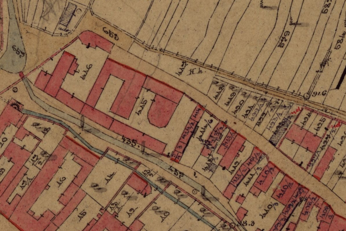
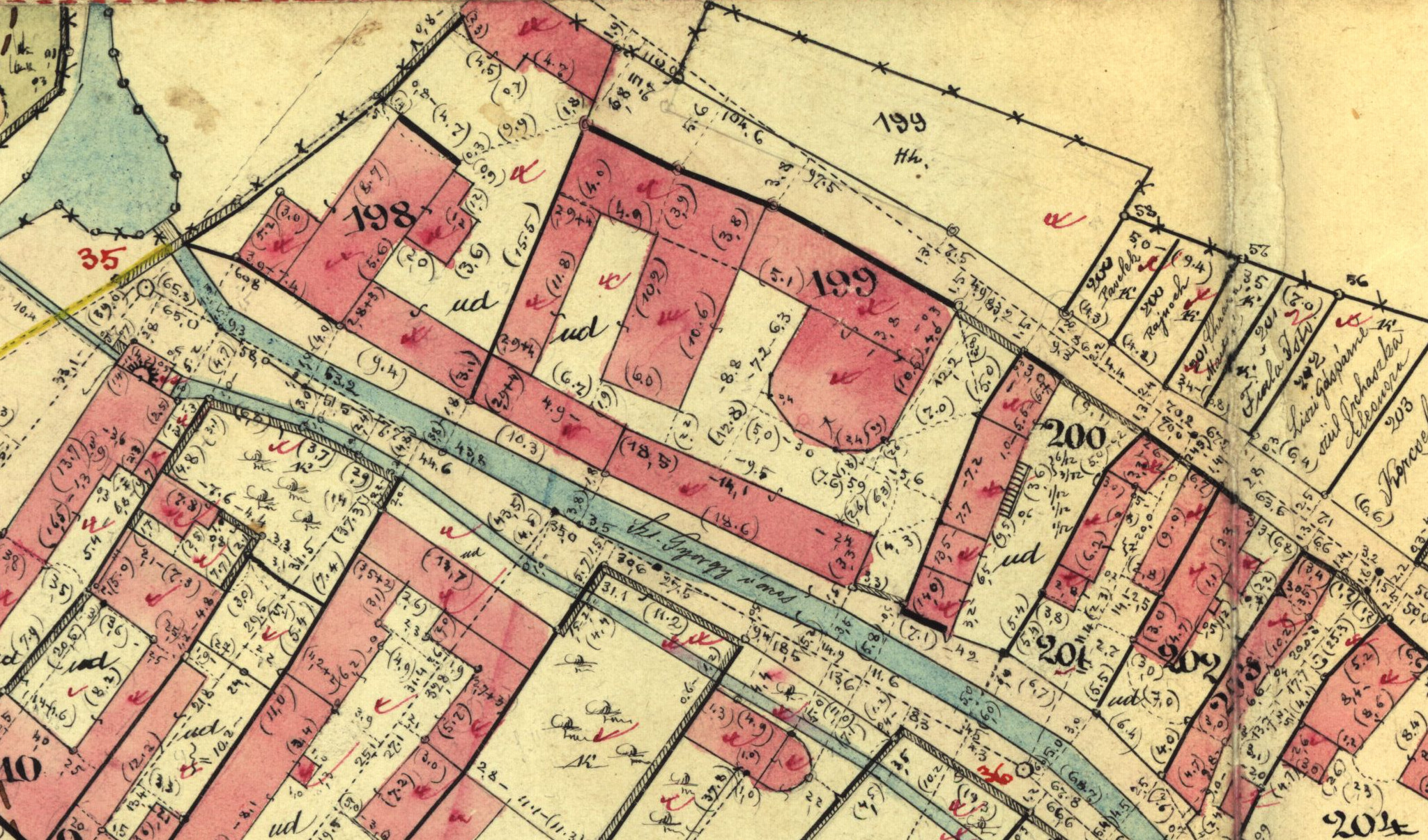
- Cadastral maps – large scale situational maps showing parcel outlines and the overall layout of cadastral territories.
- Field sketches – detailed survey drawings derived from cadastral mapping containing parcel outlines, parcel numbers, land types and boundaries. They include measurement points, distances, angles and other surveying information. Very often they also contain the names of landowners for gardens, meadows and other parcels from the period when the maps were created.
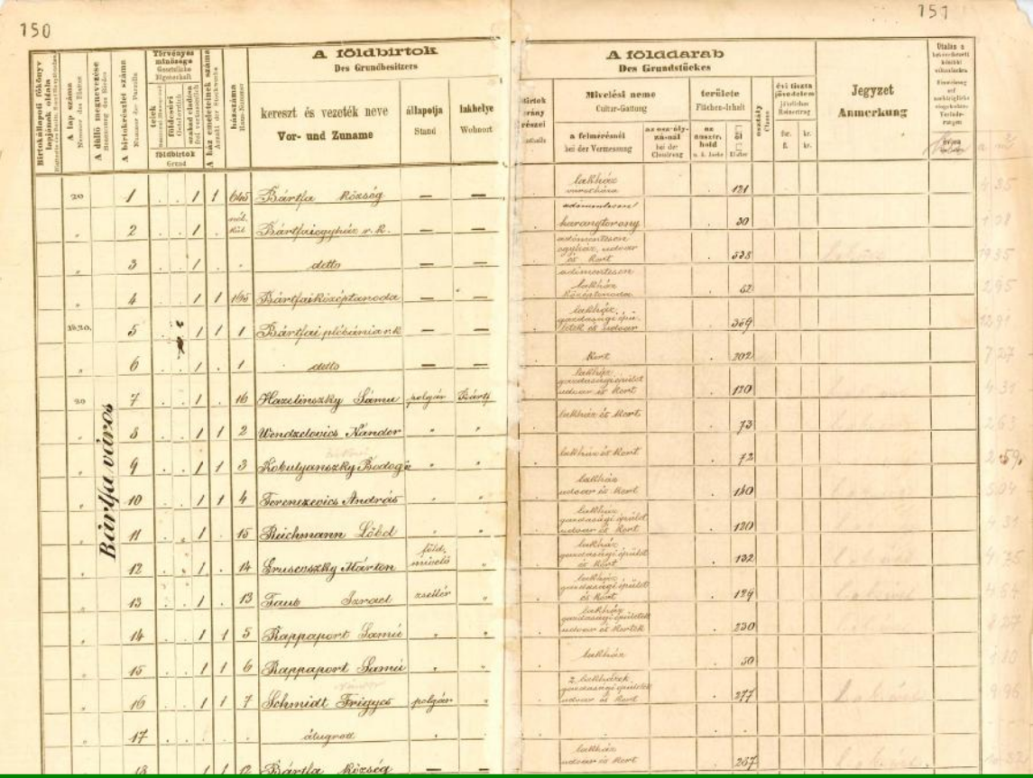
- Parcel register – the written part of the cadastral records containing a list of parcels (parcel number, area, type of land and ownership information according to the time of creation).
How to quickly view the current parcel situation online
The ZBGIS map client with the theme “Real Estate Cadastre” allows users to view parcels, measure distances and export simple map images. This procedure is explained here:Real estate cadastre and genealogyAccess to the research room
Before visiting the archive it is important to carefully consider which materials you need and prepare a list. Notes can be taken in the research room free of charge, but photographing documents with your own device is generally not allowed.Research room address (GKÚ / ÚAGK):
Geodetic and Cartographic Institute Bratislava (GKÚ)
Chlumeckého 4
827 45 Bratislava
General contact e-mail:
gku@skgeodesy.sk
Chlumeckého 4
827 45 Bratislava
General contact e-mail:
gku@skgeodesy.sk
How to obtain access to the research room:
Send an email to uagk@skgeodesy.sk describing the topic of your research (cadastral territory, time period and types of documents mentioned above). Ask about available research dates, options for ordering copies and the current price list. Opening hours and operating conditions should always be verified in advance. Some catalogues and metadata are also available through the national geoportal. On site you will fill out a research form and specify the archival collections. After the materials are located you can order digitized copies.Obtaining digitized copies
Archive staff are very helpful and will explain the entire process. It is generally not recommended to photograph materials with your own equipment. For approximately 3.50 € you can obtain a high quality scan in TIFF format. Scans of cadastral maps (black-and-white raster CIT or color JPG/TIF) and coordinate transformations to the S-JTSK system are available. Maps often include a text protocol describing transformation parameters. Copies of written cadastral records (parcel registers, calculation protocols and boundary descriptions) are also available depending on the archival collection. Digital files are usually delivered electronically by email or online storage depending on file size and the agreement with GKÚ. Printed map outputs are available in sizes A4–A0 and are useful for genealogical studies and publications. Due to a cyber attack on the Slovak cadastre system, files are no longer stored on USB drives and are delivered electronically instead. However the delivery is usually fast. Prices are not high and the archive will usually send the price list upon request.References
https://www.skgeodesy.sk/files/gku/o-ustave/referaty/2013/digitalizacia_katastralnych_map_slovenskej_republiky_a_tvorba_ich_metaudajov.pdf https://www.gku.sk/files/gku/produkty-sluzby/kp_gku.pdfMarián sent me:
All the collections of Historical Maps are at Slovakcarto
The table of contents is at gos.fns.uniba.sk